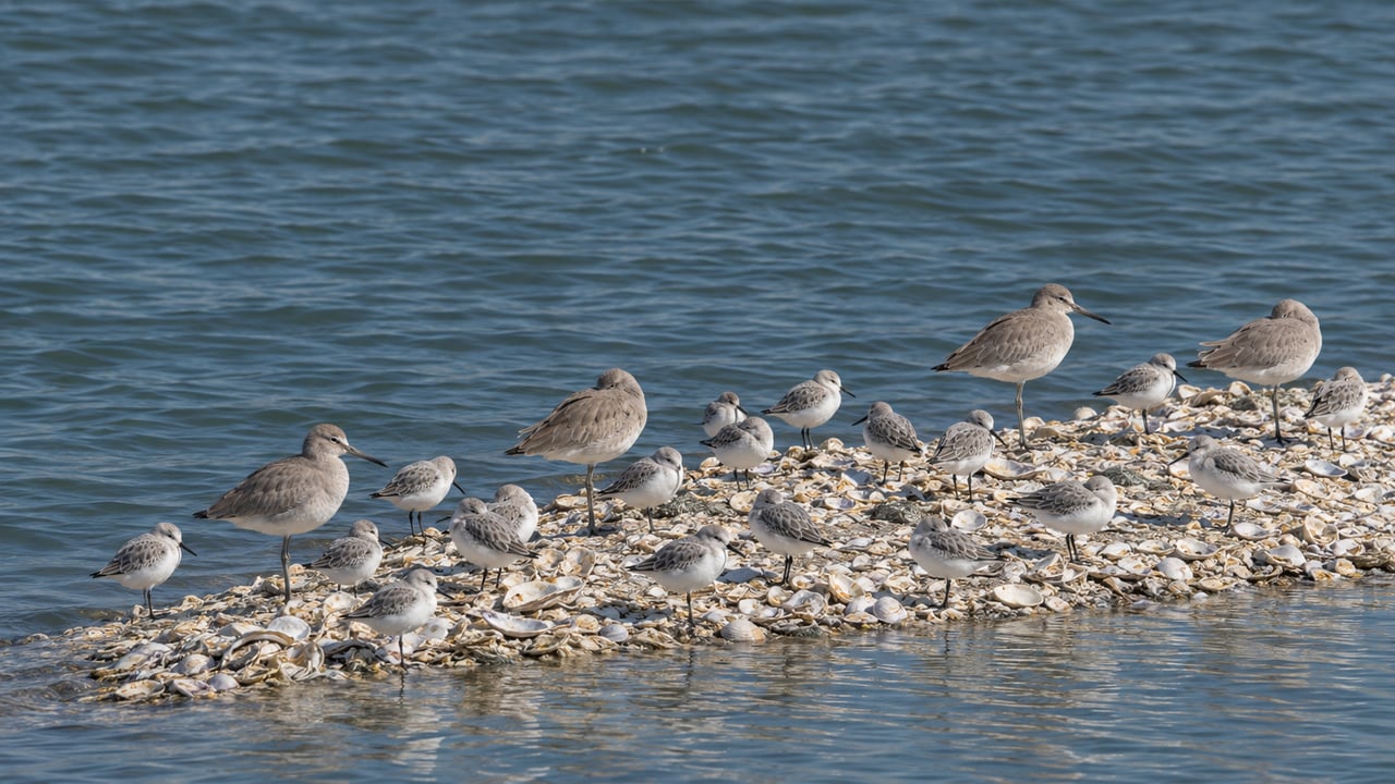
Most advice about birding in Foster City points you toward early morning. The Sequoia Audubon Society's county birding guide says the city's main spots can be covered in half a day and that "morning is best." This winter, the best hour at the Shellbar comes later. On each of the season's eight statewide king tide dates, the high tide at the San Mateo Bridge peaks between 10:39 a.m. and 12:35 p.m. At those hours the rising bay covers the mudflats and pushes thousands of shorebirds onto a strip of shells off Beach Park Boulevard, close enough to see from the levee path.
The first king tide arrives Tuesday, November 24.
What the Tide Does at the Shellbar
The Shellbar is a spit of clam, oyster and mussel shells that sticks out into the bay about a mile south of the San Mateo Bridge, along Beach Park Boulevard on Foster City's eastern edge. The Sequoia Audubon guide calls it one of the best places in the county, "even in all of Northern California," to watch shorebirds.
The reason is the tide. As the water rises, birds that were feeding out on the flats run out of exposed ground and gather on the highest dry spots nearby. From September through April, the guide says, thousands of shorebirds rest on the Shellbar at high tide. The best viewing is just before and just after the peak. A higher tide leaves the birds less room, so a king tide packs them in more tightly than an ordinary high tide does.
That makes the hour of the peak more important than the time of day. On each of these dates the bay has two high tides, and the two are very different in size. On November 24, NOAA's San Mateo Bridge west-end station predicts a 6.5-foot high just after midnight and an 8.9-foot high at 11:00 a.m. On every king tide date in the table below, the bigger tide is the daytime one.
The Season's King Tide Peaks, Station by Station
The California Coastal Commission's King Tides Project lists the statewide dates as November 24 to 26, December 23 to 25, and January 21 to 22. It adds that Northern California locations may also see qualifying tides on December 22, January 20 and January 23. The midday peaks below come from NOAA's predictions for station 9414458 at the San Mateo Bridge, west end, the closest station to the Shellbar.
| Date | Day | Predicted high tide | Predicted height, ft MLLW |
|---|---|---|---|
| Nov 24, 2026 | Tuesday | 11:00 a.m. | 8.88 |
| Nov 25, 2026 | Wednesday | 11:46 a.m. | 8.96 |
| Nov 26, 2026 | Thursday, Thanksgiving | 12:35 p.m. | 8.85 |
| Dec 23, 2026 | Wednesday | 10:43 a.m. | 9.10 |
| Dec 24, 2026 | Thursday | 11:36 a.m. | 9.13 |
| Dec 25, 2026 | Friday, Christmas | 12:30 p.m. | 8.99 |
| Jan 21, 2027 | Thursday | 10:39 a.m. | 9.08 |
| Jan 22, 2027 | Friday | 11:34 a.m. | 9.10 |
The peak moves about 45 minutes later each day in a series, so Thanksgiving's high tide comes after noon. The highest predicted tide of the season, 9.13 feet, falls at 11:36 a.m. on Christmas Eve. If you arrive half an hour before the peak and stay half an hour after, every date on the list makes for a midday walk, starting no earlier than 10:09 a.m. and finishing by 1:05 p.m.
These are predictions. The Coastal Commission notes that storm swells can raise water levels, and that actual heights may come in above the predictions this winter because of El Niño and Kelvin-wave conditions.
Where to Stand Along Beach Park Boulevard
The rebuilt levee changed how you reach the Shellbar. According to the Sequoia Audubon guide, there are now three useful spots along the walkway, from north to south:
- Opposite Marlin Street. A large viewing area with no stairs. The guide calls this the best place to see vast numbers of shorebirds roosting on the riprap at high tide, which makes it the right first stop on a king tide day.
- Between Tarpon and Marlin Streets. A smaller stairway down to the shell beds.
- At Beach Park Boulevard and Tarpon Street. The main access point, with a large viewing area and stairs. From here you can walk the length of the Shellbar north, or south toward Belmont Slough.
You don't need to go down at all. The guide notes that the levee wall is low enough to see the whole Shellbar from the walkway. It also warns that the shell beds have no trails and aren't always stable, and it asks visitors to keep their distance so the birds aren't disturbed. On a king tide, disturbing them matters more than usual. The Coastal Commission asks photographers not to flush shorebirds that are taking refuge above the tide line. At peak water, a flushed flock may not have another dry place to land.
The path is shared. The levee trail is 12 feet of asphalt striped for a two-way bike lane and a pedestrian lane, and the posted speed limit for every user, e-bikes and scooters included, is 15 mph. If you set up a scope, which the guide recommends for Foster City birding, stand on the bay-side shoulder. Restrooms and picnic tables are at Bridgeview Park near the base of the bridge and at Shorebird Park, where Beach Park Boulevard turns west.
If you bring the dog, timing matters for that too. The city's off-leash hours at Sea Cloud Park end at 8 a.m. Monday through Saturday and at 9 a.m. on Sunday, well before any of these peaks. Shorebird Park and Bridgeview Park aren't on the off-leash list, and the municipal park code requires a leash no longer than six feet.
What Will Be on the Shell Beds
The species list explains why birders come from outside Foster City. The Sequoia Audubon guide calls the Shellbar the best spot in the county for Red Knots, which are in gray winter plumage this time of year "without a trace of red." It also lists Black Skimmers, often in large numbers. The same roost draws Willets, both dowitchers, Marbled Godwits, Dunlins, Western and Least Sandpipers, Whimbrels, Long-billed Curlews, Black-bellied and Semipalmated Plovers, and Black and Ruddy Turnstones, along with gulls and terns. Watch for Merlins and harriers working the edges of the flocks.
All three king tide windows fall in the months the guide singles out for the open bay. It names November, December and January as some of the best months for Canvasbacks, American Wigeon, both scaup, the scoters, Ruddy Ducks, goldeneyes, Buffleheads, loons and grebes. Once you've scanned the Shellbar, look farther out over the water.
The Other King Tide Spot, Up at Anchor Road
The same high water makes a second place worth visiting. At Anchor Road and J. Hart Clinton Drive, a parking lot leads up to the levee and to an observation platform the City of San Mateo built in 2008 at what is now Bay Marshes Open Space. The guide calls it the most reliable place in San Mateo and Foster City for Clapper Rails, which can be heard early in the morning and at high tide. It adds that during extreme winter high tides, the walkway and platform are good spots for the rare Nelson's Sharp-tailed Sparrow, along with Swamp and Lincoln's Sparrows, which climb up on the vegetation to escape the rising water. The PG&E transmission towers nearby are worth scanning for Peregrine Falcons, and the guide says at least one has been present every winter for many years.
At the south end of the levee, Belmont Slough gives the walk somewhere to go as the water drops. A paved path follows the slough toward Marina Lagoon, with marsh between the path and the water where the guide lists Great Blue Herons, Black-crowned Night-Herons, Great and Snowy Egrets, shorebirds and waterfowl feeding.
Counting Them on December 19
The tide schedule has one more use. On Saturday, December 19, 2026, four days before the second king tide series, San Mateo County Bird Alliance runs its Crystal Springs Christmas Bird Count. The count is free to join, and the organizers say they will usually pair first-time counters with someone more experienced. The organization has run the count since 1948, with regular annual counts since 1955. Its count circle is 15 miles across, and its history of the count says the circle includes Foster City's mudflats. Registration is on the alliance's CBC page.
If you're already out on a king tide day with a camera, the Coastal Commission collects photos for its statewide map through the King Tides Project and asks photographers to shoot within about half an hour of the local high tide. On every date in the table, that half-hour window falls within a midday walk from Marlin Street to Tarpon Street.
Robert Pedro has worked the Peninsula since 1994, and he knows that what people value about living on the Foster City shoreline often has as much to do with the levee path and the bay as with the house. If you're thinking about what a home near the water is worth today, Robert Pedro and the Signature Realty team can put together a valuation built on this part of Foster City. Get My Valuation.